|
COLD SPRING TRAIL
Monte Sano
General Trail Listing
COLD SPRING NATURAL AREA AND LOOP TRAIL
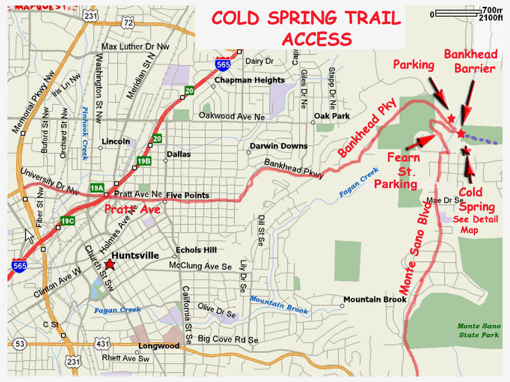
A permanently running spring called "Cold Spring" is the main feature of this property. The history and importance of this spring is discussed below. Most signs and text about this area use the plural "springs" even though there is only one spring. The Cold Spring Natural Area is a small property tucked in between Monte Sano State Park and the Huntsville Land Trust (HLT) . It is bounded by Fearn Drive, Closed Bankhead Drive and the State Park. According to the entrance sign, management is a cooperative effort between the City and the Land Trust. From the small parking area on Fearn Drive, take the trail downhill, which is identified by HLT diamond markers as "Cold Springs Loop". This loop takes you on a circuit that includes the spring and numerous specimens of old growth trees and other plants. Signs provide names and uses of the various trees and plants. When the junction with the Cold Springs "Trail" is reached, take the right branch to stay on the Loop. The trail ascends steeply, eventually reaching Cold Spring and then a level leg back to the parking area. The loop is billed as taking 20 minutes to complete. Realistically, if one read the signs, spent a few minutes at each observation site and maybe take a few photos, the walk could take an hour. The trail is on a mountain slope, so has some ups and downs. The trail surface is not as smooth as mountaintop trails such as the North Plateau. One place requires a scramble across a deep stream bed. In spring, many wildflowers are in bloom including Bloodroot, Hepatica and Toothwort. The portion of the trail between the spring and Fearn Parking lot was formerly infested with winter honeysuckle but was cleared by the Sierra Club.
COLD SPRING TRAIL
Several years ago Carl Craig flagged a route that connected the Cold Spring Natural Area with the North Plateau Trail on the mountaintop. This trail, which is within the State Park, is identified as the Cold Springs Trail (as opposed to Cold Springs Loop for the Natural Area). This trail has red blazes that are now much depleted. This trail also has spring wildflowers, especially Bloodroot. This trail can be accessed via the loop from Fearn Drive or by walking about 1/4 mile up the closed Bankhead from the parking lot at the barrier. Watch for a faint pathway from the road up to the trail, which passed close by at this point. The Cold Springs Trail does involve some elevation change. The closed Bankhead can be used for an easier return trip to the originating parking lot.
COLD SPRING NATURAL AREA DESCRIPTION
Description from the sign at the Fearn Drive Parking Area:
"Boy Scout Troop 303 of Trinity Methodist Church. This Eagle Scout product is an effort to create an outdoor environment in which the community could learn, relax, and enjoy the beautiful Huntsville landscape. The Cold Springs area is an old growth forest. a group of predominantly deciduous trees that have attained canopy stage. The species of trees found here in Cold Springs are common to the North American old growth forests. Buckeyes, tulip trees, hickory trees, basswoods, dogwoods and a variety of oaks can be found along the trail. In addition to the trees there are many types of plant life found here which are identified by the trail signs such as ferns, poison ivy, greenbrier, hydrangea and grapevine. Part of the trail near the springs is an old wagon trail, which dates back to the mid 1800's. The trail was used as a passageway through Monte Sano Mountain and also as an access road to the Monte Sano Hotel, which existed on top of the mountain near Fearn Street in the late 1800's and early 20th century. The spring was used as a water source for the railroad that ran up the mountain. Please take time to walk the trail and examine this unique and historical area. The loop takes about 20 minutes to complete. We hope you enjoy the trail and spread the word of its existence to others who might enjoy it. This property was obtained by the city of Huntsville through a grant from the Land and Water Conservation fund."
Original trail built by: Jesse Dickson, Eagle Scout -- Trail renovations by: John Bryant, Eagle Scout."
COLD SPRING NATURAL AREA GEOLOGY
Geology Information from the sign at the Fearn Drive Parking Area:
"Cold Springs is one of the few permanent springs high on Monte Sano. It is fed by rainwater caught on the sandstone cap rock of Monte Sano. It is fed by rainwater caught on the sandstone cap rock of the mountain. This rainwater filters down through the sandy soil of the mountaintop until its progress is blocked by the underlying impermeable sandstone. Groundwater is either forced laterally to seep over the plateau edge or is focused through one of the few cracks in the sandstone. Water penetrating the sandstone is weakly acidic from carbon dioxide picked up from the atmosphere or in the soil. This weak acid dissolves the underlying limestone and creates subterranean pipes and channels. The cave channel supplying Cold Springs is carved through the pennington limestone boulders which you see above the spring. The water is forced out of the spring by shale and clay layer that makes the bottom of the pennington geological formation.
Since Monte Sano, like the rest of the Cumberland Plateau is largely composed of a limestone layer, the water which comes out at Cold Springs does not stay above ground long. The water quickly returns through cracks and solution channels to continue carving the cave system below, redepositing calcium carbonate as stalactites, stalagmites, and various forms of flowstone as circumstances dictate.
As a result of the creek channel is usually dry 25 meters below Cold Spring, except after rains. Regions with limestone bedrock like ours are called Karst Terrain (after a region of Bosnia) and typically have few surface streams, since most water flows through cave systems, some of which may be spectacular.
Since surface water is rare, sites like Cold Springs can be very important as watering holes for wildlife. Deer, for example, seldom live more than 1/2 mile from a water source."
"
Access ...
Trail Map...
Photos With Flowering Dates |